Showing posts with label Malaysia. Show all posts

Friday, 20 January 2023

Bahasa - English Chart Text Cross Reference

 A simple cross reference, Bahasa to English for the most commonly used text descriptors when using charts in the local language. However in most cases the charts, either electronic or paper for Indonesia and Malaysia will use the Bahasa names to give detail to the chart. We printed it, laminated it, and kept it near the chart table/radio and also did one for the cockpit  chartplotter. 

Batu            (Br) Rock
Bukit          (B)        Hill
Gosang      (Gs) Bank, Shoal
Gunung      (G) Mountain
Kantangan         Mud Flat
Karang       (Kr) Reef
Palau          (P) Island
Puncak         Peak
Selat         Strait
Tanjung      (Tg) Point
Teluk         (Tk) Bay
Ujung       (Ug)      Point
Besar         Big
Kesil         Small
Laut         Sea

We also made really good use of the Google Translate App however you need a phone/internet connection to make it work. 

Tuesday, 27 December 2022

Rough Guide to Monsoon Seasons, AU Top End & SE Asia

Weather, Almost everyone we talked to when we went into SE-Asia were a little confused when trying to work out the reasons for the two differing wind directions for the one monsoon season. The Intertropical Convergence Zone, or ITCZ, is the region that circles the Earth, near the equator, where the trade winds of the Northern and Southern Hemispheres come together. Sailing up in this area can be difficult at times, however if you can get a handle on the basics it really helps especially as some voyages will start in one hemisphere and end in another. 

Indonesia spans across the equator and you need to take this into account when you are reading about which weather patterns fall in which month. We didn't one time and as it turns out were not pleasantly surprised. Indonesia doesn't get a summer or winter its either the wet season or dry season the notation on the list below is more to denote the hemisphere season. Also of note is the dry/wet is not the whole of Indonesia in the same season.


Southern Hemisphere Indonesia                              Northern Hemisphere Indonesia
N-West monsoon Dec-Jan-Feb   (S Summer)          N-East monsoon Dec-Jan-Feb     (N Winter)
First transition Mar-Apr-May                                  First transition Mar-Apr-May
S-East monsoon Jun-Jul-Aug     (S Winter)             S-West monsoon Jun-Jul-Aug     (N Summer)
Second transition Sep-Oct-Nov                                 Second transition Sep-Oct-Nov


Bruce's rough guide to the monsoon seasons on both side of the equator. 

Winds change through the year.

During December and January, the Southern Hemisphere is heated more strongly by the Sun than the Northern Hemisphere, so the hottest air — the air that rises in the ITCZ — is found south of the equator. Winds from the Northern Hemisphere blow across the equator toward the ITCZ.

During June and July, the Northern Hemisphere is heated more strongly by the Sun, so the ITCZ and its rising hot air lie north of the equator and winds blow from the Southern Hemisphere across the equator to reach the ITCZ in the Northern Hemisphere.

As the ITCZ changes location through the year, the winds and rains and the location of monsoon wet weather changes, too.

-----

Remember that the Coriolis force changes direction on the equator: It turns winds toward the right in the Northern Hemisphere (so a SE in the Southern Hemisphere turn SW in the northern Hemisphere) Wind turns toward the left in the Southern Hemisphere (so a NE in the Northern Hemisphere becomes North West in the Southern Hemisphere).

So when air crosses the equator as it flows from the cold winter hemisphere toward the ITCZ in the summer hemisphere, it experiences a change in the Coriolis force. This causes the trade winds to reverse direction and blow toward the west in the winter hemisphere and to the east in the summer hemisphere.

This seasonal reversal of the winds was historically very important for trade between Africa and Asia. Ships would sail from Asia to Africa in winter and then undertake their return voyage when the summer monsoon changed the wind from westward to eastward.

Winds within a couple of degrees of the equator are generally “light and variable” all the time. Weather forecasts are rarely accurate in these areas. Make sure you have a cruising spinnaker and as a back up, an engine. Winds are spasmodic and currents are/can be quite strong depending where you are.

------------------------

SE / SW Monsoon Season
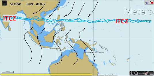
While the drawing I have done is a little rough I hope the fundamental idea makes sense. 

During the months of June-September dry season trade winds blow consistently from the SE and ESE throughout the Southern Islands of Indonesia. Trade winds are stronger in Eastern Indonesia and areas around Timor and the Arafura Sea than they are further to the West near Lombok, Bali, Java and Sumatra.

Further North as SE trade winds approach the equator they lose considerable strength and veer from SE to a very light S. Then, once across the equator and into the northern hemisphere, due to the Coriolis effect, these light S winds again veer from S to SW and slightly increase in strength. It is for this reason that we sometimes refer to this season as the SE/SW monsoon season.

Precipitation on both sides of the equator is at odds. While Bali and Java experience dry season trade winds out of the SE, the areas of northern Sumatra, Kalimantan, Sulawesi, Morotai and Thailand will be in their SW monsoon wet season.

NE / NW Monsoon Season


During the months of December-February NE winds blow in the northern hemisphere and across the top of Indonesia. As these NE winds approach the equator they lose strength and back to the N. Once across the equator, because of the Coriolis effect, winds back further and increase in strength to become the NW monsoon wet-season for much of Southern Indonesia. Southern Sumatra, Southern Sulawesi, Java, Bali, Flores, Timor, and Rote will all experience strong westerly winds and rainy conditions for much of this period with the height of the wet season falling in February.

Clear sky's and calms are often experienced in between passing storm systems.

Cyclones can develop in the Timor, Coral and Arafura Seas and this area should be monitored if passing near Timor and Rote Islands during the NE/NW monsoon season.

Transitional Seasons

Some nice cruising can be had during the changing of the seasons. Winds are often light to non-existent with only short duration squalls passing through. Some of the more exposed and windy areas of Indonesia are often calm and pleasant and open to exploration at this time. With the sun directly over the equator and calms likely, conditions can be very hot. The ITCZ can move by as much as a thousand miles overnight or not move at all and sometimes will appear in two places at once. With such changing conditions occasional late or early season weather does develop.

--------------------------------------------

We have found that neither the GFS nor the ECMWF do a good job of forecasting winds in Indonesia. Generally they get the direction right, but wind strength is hit and miss. Weather forecasts (GRIB files) in the Malacca Strait never seem to be right either, perhaps this is just our observation because, we possibly never got far enough off shore to get away from its effects.

Here is a reasonable explanation of the monsoon seasons:

https://www.abc.net.au/news/2019-01-18/monsoon-explaining-the-complex-weather-phenomenon/10722716

Malacca Strait

The weather description below is for the Malacca Strait (Selat Melaka), being a passage between Peninsular Malaysia and Indonesian Sumatra there are a couple of anomalies. When using any of the Island anchorages, be prepared to get underway at a moments notice. After being caught, we would work out an action plan to get to the other side quickly. If we were lucky, once the front passed there would be a calm for a couple of hours after the storm, before the wind returns to its original direction.

Northern Hemisphere Melaka Strait

Northeast Monsoon - November to March

This is the dry season. The winds are predominantly from the NE from 10 to 20 knots, with occasional winds up to 30 knots. There are frequent calms lasting from a few hours (often in the evenings and early morning) to whole days or a few days duration. Rain is very rare and the days are fine and relatively cool as the sun is at its furthest south at this time (in December the sun is only 60 degrees above the horizon at midday) - Very pleasant cruising weather and because the wind is coming straight off the Malaysian peninsular there is no swell and any seas that do come up during local strong winds drop quickly when the wind drops.

Transition period - April and May

This is the height of the transition period between the NE and SW monsoons and is marked by many calms, very light winds and flat seas. When there is wind it can come from any direction and vary in strength and direction, but is not common from the East through to South or from the North. There is the odd rain squall that can last from five minutes to an hour or two with winds sometimes up to 25 knots under them.

Very little chance of a "Sumatra" (see SW Monsoon). Hot, sultry weather.

Southwest monsoon - June to September (Some years into late October)

This is the wet season. Hot, sultry weather as the sun is in the North and the humidity is high. The winds are predominantly from the SW from.10 to 25 knots, with frequent calms and frequent rain squalls. The rain squalls last from a few minutes to a few hours but typically last for about 15 minutes with very heavy rain and either no wind or, more frequently, winds up to 25 knots. These winds change strength and direction depending on your position relative to the centre of the squall.

Once they have passed over, the skies clear and the wind returns to its condition before the squall arrived. A squall can usually be seen well before it arrives as an isolated large, dark, towering cloud and, should you be close to land or rocks, gives you plenty of time to either anchor or head for an open area before the heavy rain causes a complete whiteout.

This is the season for "Sumatra" winds.

"SUMATRA" winds are a different matter altogether. In the day they can easily be identified as a long rolling bank of very dark cloud extending roughly North and South from horizon to horizon and coming from the West from Sumatra, thus their name. At night, when they are most common, the first warning is when they hit. They are most common in the South Malacca Straits, but do occur occasionally around Penang ,and Langkawi, though they are rarer around Phuket. Typically there will be two to four during this season in Penang and one or Penang and one or two in Phuket. There is no avoiding the very strong (up to 60 knot)\ Westerly quarter wind that just precedes the cloud bank and very heavy rain. They can last for five or more hours, though more commonly last for from about 20 minutes to one hour and then end as quickly as they began.

Transition period - October

Same as the Transition period from April to May.

This is the height of the transition period between the SW and NE monsoons and is marked by many calms, very light winds and flat seas. When there is wind it can come from any direction and vary in strength and direction, but is not common from the East through to South or from the North. There is the odd rain squall that can last from five minutes to an hour or two with winds sometimes up to 25 knots under them.

Very little chance of a "Sumatra" (see SW Monsoon). Hot, sultry weather.

----------------------------------------------------------------

“Red sky at night sailors delight; red sky in the morning sailors take warning.”

There is a simple explanation for this. When the sun is on the horizon, its light, shining at an angle, must pass through more atmosphere.

Red is the colour of the spectrum with the longest wavelengths and can therefore reach all the way through to where water vapour and dust is denser. Here it reflects off the vapour and dust projecting a red light to our eye. In mid latitudes storms predominantly move from west to east.

“Red sky at night sailors delight" So when the sunset in the west reflects off particles of a low pressure in the east, creating the red lit sky, the weather has past making way for improved (delightful) conditions.

"Red sky in the morning sailors take warning" So then if the sunrise in the east reflects off particles of a low pressure in the west, making the red lit sky, we can assume that storms are approaching, sailors take warning the weather should worsen.

Friday, 24 May 2019

The Cameron Highlands


Over the last few years we have watched with interest many friends take the trip up to Malaysia’s highest point by road, the Cameron Highlands, and now we have followed suit. Armed with loads of tips from our friends we decided to do a two night, three day visit. One of the best pieces of advice was to not visit the highlands on a weekend. Good advice as we did head up on a public holiday and came home on a public holiday, but we did not experience any high volume traffic. 

Close up of a tea plant.


Also, we timed our visit with Ramadan, a religious time of fasting for Muslims during daylight hours. This time of fasting meant a lot eateries where shut during the day. And just to top off the excitement we both left with colds, which was unfortunate as we were bound for a much cooler climate and we don’t carry any warm clothes anymore. One thing that was upsetting was quite literally as we were leaving Matilda we noticed a mouse (god forbid it’s a rat), had been chewing on a loaf of bread, not good.


One of hundreds of Land Rovers we saw on our visit.
So 6 cans of bug spray later we closed up Matilda and took off for our 3 day sojourn. As a tip we have found rodents do not like insect surface spray at all and will abandon ship.  Our little hire car went like a champion giving us terrific fuel economy. It was great to be on the southern bridge, or the second bridge (odd term as is it the second from the south or the north?). It’s official bridge name is: Sultan Abdul Halim Muadzam Shah Bridge and is some 24 km’s long, lending itself to being the longest bridge in Malaysia and also the longest in South East Asia. The view looking east was stunning.

Great shot of the southern bridge linking Penang to the mainland.

We saw a few happy couples saying their 'I Do's'...amongst the tea plantations.
We left from Batu Uban Marina which is a government run facility and very well priced (as long as you don’t use a lot of water. At RM2 per 10 litres, that soon adds up). Our journey from the marina to our hotel took us around 4 hours. This included 1 stop for drinks, snacks and the loo and 1 other stop for a late lunch. The return journey with no stops took us 3 hours. You will need a Toll Card to cross the bridge and travel the highway. The charge was around RM17.60 on both legs.

Batu Uban is the marina where we left Matilda while we went to the Cameron Highlands.

Another one.
The highway to Ipoh was excellent and the road up the mountains was in very good condition. Construction of the road started in 1928, taking 2 years to build. Although the passing traffic was at times scary. I think we saw some of the most dangerous over taking situations we have seen since being in Asia, just downright dangerous. If you drive up yourself, always keep to your left, because those coming in the opposite direction will assume you will be out of their way as they whiz around others on blind corners and long winding bends. As we got higher the rain started which meant we couldn’t see any of the views, but it was glorious driving so high up in the clouds.

These are the workers cottages at the BOH tea plantation.

Tea as far as the eye can see, well almost.
As you approach the highlands it soon becomes obvious this is an incredible place. Ipoh must be the grand home of all things granite, marble and lime stone. They are literally carving out entire hill sides, taking the tops off the mountains and gauging huge scars in their mountain sides.  Apart from what must go on, the views of the limestone karats where spectacular. Then as you reach the top of the mountain ridge, the hydroponics are in mass. It’s like someone went berserk with the canopy nurseries. They cover every square inch of the hillsides, they mass the valleys and where it’s just too step they have actually built out structures so they can make man made growing fields. It’s mind boggling.

Taken from inside the car, the gauges in the mountain sides where substantial.

This shot was taken on the road to the Mossy Forest. The hydroponic tents all had vegies in them.

Not sure you can see it but mid centre is showing how they build these structures out on difficult terrain so they can keep growing.

This is showing the hydroponic tents running all the way up one of the many valleys.
Next are the townships. We are sure that many years ago the mountain communities where quaint with very endearing English Tudor style homes and hotels as it was commissioned to be a retreat mountain destination some 70 years ago. Now it’s totally out of control. Some of the roads are in bad condition in some parts due to the sheer volume of truck traffic and the water run off is alarming. We passed what was most likely the one main stream, which was quite wide in some parts and in the most gorgeous setting, but the water was the colour of clay, as there are no run off laws here. The rubbish was alarming. Some of it was so thick in some parts, the natural water flow was obstructed by the sheer volume of plastic, jute and hessian bags. The housing is mayhem, with structures appearing everywhere, some areas resembled shanty towns.

It had just started to rain and this guy was ready for it!

With much infrastructure being built the roads are suffering badly.

Another couple,,,,,
As you approach the town of Tanah Rata, which is the main township for the Cameron Highlands the craziness does subside to some degree but it’s fast becoming the same as its neighbours. If someone doesn’t control it soon, they will lose what little remaining charm it currently has. Something that was immediately obvious as one of the last remaining remnants from the Brit’s is their love of Land Rovers. There must have been 100’s of them everywhere we looked. It was incredible.


Yep, another one.
The area was first recognised in 1889 as a suitable area for a sanatorium, health resort and farming lands. Later during 1925 an experiment station was set up to grow: tea, coffee, fruits and vegetables. It was successful and construction of the road in was started not long after, in 1928. The British moved in bringing their love of tea, strawberries, roses and Tudor style housing, the rest is history. All these legacies are still remaining, but the farming is now in mass, the Tudor housing is still there, but now they build with the same facade as the old style, but it’s not the same when it’s on ten story apartment blocks.


We had decided to wing accommodation until we arrived, as there is so much to choose from in the highlands. After doing much internet research over our rissole sandwiches (on a freshly brought loaf) we chose The Casa dela Rose. A very good price was secured thanks to booking a room via Agoda. The hotel proved to be a good choice. We had a king size bed – quite a treat coming from our boat bed. A lovely view out of our window and our room had a bathtub. I (Deb) do miss not having a bath as a live on board. It was lovely and I got to have two very long hot baths – bliss. Being in a cooler climate we got to snuggle with a donner, ahhh it was lovely. The location of the hotel was glorious with beautiful vistas and very little traffic noise.

Our choice of hotel - swanky hey!!


The view out the front of our hotel.
Our full day was packed with enjoying the scenery and taking in all the local attractions. On our hit list was: a visit to The Lavender Farm, see some butterflies in a butterfly farm, go to a Cactus Farm, enjoy a dinner of Beef Wellington, a walk in the Mossy Forest, some bird watching, call into a strawberry farm, a visit to the local Buddhist temple, see the tea plantations and take in loads of scenery. We did make the decision to not pay to get into anything we had already seen elsewhere, being budget conscious we wanted to watch our spending’s.


This shot is zoomed right in, the haze is a bit thick. Its one of the many Tudor style houses amongst the tea plantations.
After a good night’s sleep, a lovely long hot shower and our complimentary breakfast we took off. It was nice to be in a cooler climate with a few more layers on. Our first target was to see a tea plantation or several. As you drive around, the mountain sides are covered in tea plantations. We headed off to the Cameron Highlands Tea Plantation. It was very impressive. You can stop along the winding road safely, jump out and take photos. Incredible views. It was the first time we had both seen tea plants, and were quite taken with the aerial view. But the plant itself is quite gnarly and we can only imagine how tough life is to be a tea picker as they walk among the bushes. They must get so many scratches and damage to their arms, hands and legs. We wanted to enjoy a local tea at a quaint tea house overlooking the plantation but as our life dictates the tea house was closed on Tuesdays!

You guessed it,,,another one.


The Lavender Farm which is a huge complex, has the tightest car park in history and they wanted to charge us on entry, so we declined our visit as we both know what lavender looks like, instead we took some photos out the front and took off.


Then it was off to the Mossy Forest for a walk, it was highly recommended so off we went to that. The road in was shocking and it didn’t get better. We did drive in for quite some time but it got to a point where the road was so bad we turned around. It’s been ruined by torrential rain, no road maintenance and quite large trucks moving local produce down the mountain.

The road to the Mossy Forest in a shocking state.
But it did put us in position to go visit the BOH tea plantation as its on the same road. Their plantation like the others is vast covering immense mountain sides. It was lovely to see some pickers out and we even saw a few brides having their photos taken amongst the tea bushes. The Mossy Forest is a well-known birding site which we were looking forward to, but we didn’t make it in. we did however see some very lovely little birds and managed to capture photos of them.

The road to the Mossy Forest, it was a hint of what was to come.

BOH's tea plantation.


Inside their shop which is a new addition and was still under construction as we walked around.
This was our choice of tea from BOH - their ginger & lime tea is really lovely.

Oh, another one.

White bags full of tea ready to be shipped out.

A shed in the BOH grounds and on the road to the Mossy Forest, love the roof!

Workers scattered on the hill side.


Tourist viewing platform built inside the tea plantation grounds
The foliage was so green everywhere we looked. Everyone’s plants and gardens where spectacular and the golf green opposite our hotel made for a lovely view during breakfast. It’s easy to see how the nurseries all do so well, we really loved all the colour. Bruce loved seeing so many orchids growing in the wild.


Oh dear, another one.


There are strawberry farms galore up there. We didn’t stop at these, we know what strawberry farms look like but it was mind boggling just the same. Their claim to fame for the tourist is to ‘pick your own’ and it seems to be working well with the Chinese tourist. We did want to see the Butterfly Farm but after seeing them we declined. They were in a sad state and not sure if any butterflies where going to be in there. We did however go to see one of many cactus farms. I was quite amazed they grew so well in such a cool climate. They are a fascinating little plant, well some not so little and their flowers are beautiful.


I love the tones of this plant - I have not edited this photo at all.

This is my favourite photo of the entire trip. This to me looks like a family of cactus with a mum and dad, a teenager and 2 toddlers.


Then off to the well-known Sam Poh Buddhist temple. This took some finding as the shanty towns have been built over the roads that Google maps knew. So after much mucking about up some very tight streets we found the temple, only to get there and find it in a state of refurbishment. We couldn’t even get into the car park, so that was a quick visit.


No its not a blury photo, its pouring with rain. This was as much of the Sam Poh Temple we could see.

Another one hahaha.
We also went to visit one of many water falls but by the early afternoon the skies had opened up, it was raining so hard we actually pulled over at one stage. The rain doesn’t slow down the local trucks or cars and their overtaking antics were something we were happy to let go by. The rain didn’t subside so we gave a walk into the waterfall a miss.


Once we realized the torrential afternoon rains were settled in we retired our driving around for the day, where we felt a bit safer back in our hotel room. Thanks to Bruce’s forethought we enjoyed a few beers, watched some sailing YouTube videos and then went down for dinner. Giving our original thought of devouring beef wellington a miss, as we would have been soaked just getting in and out of the car. So down to the hotel’s restaurant it was, we were the only guests. Our dinner of chicken chop with vegies and a Caesar salad was lovely. A nice end to a busy day of sightseeing.

This was the view out the back of our hotel room.


To finish off our last day we went down for our complimentary breakfast only to find we were the only ones there again, talk about feeling special. We had a lovely American Style breakfast freshly cooked for us. We checked out and made our way back to Matilda. No rain on the drive down, which meant we could take in the views which were stunning. We are so glad we went to experience the highly recommended Cameron Highlands, although wondering how much different it was looking back say 50 years. It was interesting to read that the Cameron Highlands is to this day remain Malaysia’s most popular tourist destination.