
GPX (GPS Exchange Format) the file extension of one of the most commonly used GPS file formats now days. If you need to edit or manipulate GPS data files, or old types, here is several programs that should cover most formats. In no particular order, all are free downloads at the time of publishing.
I have used EasyGPS and Garmin Mapsource for several years to communicate with my handheld GPS, I can download and upload waypoints tracks and routes to my units. Great for doing back ups of the waypoints on the unit and saving the tracks and routes. Recently I uploaded the Sail Malaysia Cruising Guide GPX file to my Garmin GPS 73 using Mapsource, the waypoint icons are not the same but for a screen size of the handheld it doesn't really matter.
I have used Mapsource to repair broken tracks and edit waypoints, there is also a function to display the routes, tracks and waypoints on Google earth. However you need to be running an older version of GoogleEarth for communications between the two programs, I use Google Earth Pro_7.3.1.45 because it will still allow the files to be transferred to GoogleEarth.
Keep in mind all the nice waypoint symbols now available in OpenCPN will be lost if you open and save the GPX files with any of the programs listed.
------------------------
GPSbabel
I use this program to convert my Lowrance chart plotter tracks to GPX format. GPSbabel will do a lot of conversion from one format to another. One I have found useful is NMEA to GPX, great if you log data and then want to convert it into GPX format.
------------------------
EasyGPS
EasyGPS is the fast and easy way to upload and download waypoints, routes, and tracks between your Windows computer and your Garmin, Magellan, or Lowrance GPS.
-----------------------
GPX Editor
GPX See
Both handy programs to view and or edit GPX files.
The thing I like about both of these programs is they can both display the contents of the GPX file on OpenStreetMap so if you are looking at a route or track and want an idea of the overall location this is a good place to start. When passage planning in reef areas I will start with the OpenStreetMap function first then transfer the file into GoogleEarth or SASPlanet. I am liking SASPlanet more and more these days due to the function of allowing the different sources of satellite images to be displayed.
GPX See will nicely display .mbtiles and .kap (chart files), great for doing quick QC on files in your chart library.
----------------------------------------------------------------------------
Garmin Mapsource
The Garmin Mapsource is used to up and download files from Garmin products, in particular Garmin GPS H72 and the later GPS 73 handheld units. I believe Mapsource will do the whole range of Garmin handheld units, especially the ones with a USB connection.I don't have any problems manipulating and editing GPX files and as mentioned earlier have on numerous occasions joined short breaks in tracks.
However there is a trick to doing the install on your PC, here is what I do
Download MapSource software updater from Garmin.
1. Unpack or extract the content of MapSource_6163.exe download using WinRAR.
2. From the extracted files, run MAIN.msi or MSMAIN.msi.
3 Then, run Setup.exe.
Note: The sequence to execute Main.msi and then Setup.exe is important to avoid “Previous MapSource not found!” error.
Garmin MapSource now installed.
Simples.
--------------------------------------------------------------------------
For those of us who have chart plotters that can save out the sonar file or log using .SL2 format there is only program I found to be useful. Unfortunately its not free like the others listed above. The other drawback I see is that once you down load your sonar file and overlay it on the small chart (world base map) there is no way to then save it as a chart usable by the chart plotter or OpenCPN for navigation. (unless I am missing the point)
It is easy to use and may be helpful if your trying to explore new territory with the tender to take the deeper draft vessel into.
Reef Master Sonar Viewer
------------------------------------------------------------------------------
C2GPXKML Written by: Paul Higgins http://www.gdayii.ca/
(Paul has also written some neat programs, one in particular is helpful and is for converting google earth images into geo referenced KAP files for use in OpenCPN)
Purpose of C2GPXKLM is: To convert navigation routes, tracks, waypoints to different formats.
This program will accept as input the following type of files:
- SeaClear route files (.SRW)
- SeaClear track files (.TRC)
- GPX route and track files produced by other navigation programs such as openCPN and Fugawi.
- EXECL worksheets (.xls or .xlsx) in a special format. A sample database is provided.
- .G7T routes or track files.
- Maxsea .PTF and WPT
It can convert any of the above into KML, GPX, G7T, TRC, SRW formats, or update an EXCEL worksheet.
Tracks can be combined to create one large track file.
If the input is a track, you can add log data created by either SeaClear or the OpenCPN Konni Logbook plugin. See "Adding Logbook Waypoints" in the readme file when the program is unzipped.
It can also convert any of the inputs to Furuno or Raymarine chartplotter format and upload it to the chartplotter via a COM port. (see "Uploading to a Furuno or Raymarine Chartplotter" in the readme file when the program is unzipped).
If you have created link information for GPX or KML files, it will be converted to the other format (KML or GPX). See "Creating Links" in the readme file when the program is unzipped.
-----------------------------------------------------------------
The Advanced Option:
A Simple Text Editor
After posting this I was reminded by Sherry off the vessel Soggy Paws that we can use a simple text editor as long as it can recognize XML files, which .GPX files are based on . The one Sherry uses is SciTE editor downloadable from here . I have used wordpad available with Win10 on a lot of occasions, the more you use it the easier it becomes.
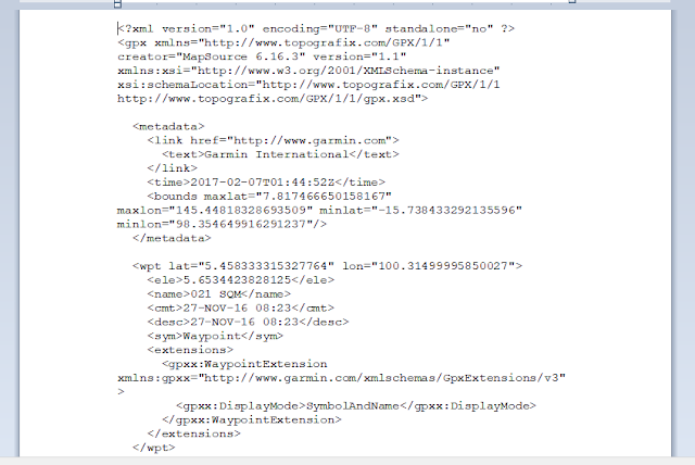
The script below is a screen grab of a .GPX file open for editing in wordpad, this wont be a solution for every one..
Garmin Mapsource
The Garmin Mapsource is used to up and download files from Garmin products, in particular Garmin GPS H72 and the later GPS 73 handheld units. I believe Mapsource will do the whole range of Garmin handheld units, especially the ones with a USB connection.I don't have any problems manipulating and editing GPX files and as mentioned earlier have on numerous occasions joined short breaks in tracks.
However there is a trick to doing the install on your PC, here is what I do
Download MapSource software updater from Garmin.
1. Unpack or extract the content of MapSource_6163.exe download using WinRAR.
2. From the extracted files, run MAIN.msi or MSMAIN.msi.
3 Then, run Setup.exe.
Note: The sequence to execute Main.msi and then Setup.exe is important to avoid “Previous MapSource not found!” error.
Garmin MapSource now installed.
Simples.
--------------------------------------------------------------------------
For those of us who have chart plotters that can save out the sonar file or log using .SL2 format there is only program I found to be useful. Unfortunately its not free like the others listed above. The other drawback I see is that once you down load your sonar file and overlay it on the small chart (world base map) there is no way to then save it as a chart usable by the chart plotter or OpenCPN for navigation. (unless I am missing the point)
It is easy to use and may be helpful if your trying to explore new territory with the tender to take the deeper draft vessel into.
Reef Master Sonar Viewer
------------------------------------------------------------------------------
C2GPXKML Written by: Paul Higgins http://www.gdayii.ca/
(Paul has also written some neat programs, one in particular is helpful and is for converting google earth images into geo referenced KAP files for use in OpenCPN)
Purpose of C2GPXKLM is: To convert navigation routes, tracks, waypoints to different formats.
This program will accept as input the following type of files:
- SeaClear route files (.SRW)
- SeaClear track files (.TRC)
- GPX route and track files produced by other navigation programs such as openCPN and Fugawi.
- EXECL worksheets (.xls or .xlsx) in a special format. A sample database is provided.
- .G7T routes or track files.
- Maxsea .PTF and WPT
It can convert any of the above into KML, GPX, G7T, TRC, SRW formats, or update an EXCEL worksheet.
Tracks can be combined to create one large track file.
If the input is a track, you can add log data created by either SeaClear or the OpenCPN Konni Logbook plugin. See "Adding Logbook Waypoints" in the readme file when the program is unzipped.
It can also convert any of the inputs to Furuno or Raymarine chartplotter format and upload it to the chartplotter via a COM port. (see "Uploading to a Furuno or Raymarine Chartplotter" in the readme file when the program is unzipped).
If you have created link information for GPX or KML files, it will be converted to the other format (KML or GPX). See "Creating Links" in the readme file when the program is unzipped.
-----------------------------------------------------------------
The Advanced Option:
A Simple Text Editor
After posting this I was reminded by Sherry off the vessel Soggy Paws that we can use a simple text editor as long as it can recognize XML files, which .GPX files are based on . The one Sherry uses is SciTE editor downloadable from here . I have used wordpad available with Win10 on a lot of occasions, the more you use it the easier it becomes.
The thing I like about editing GPX files using the wordpad is the search and replace function, I use it to change strings of data in the whole document. For example if I want to change the waypoint symbol, I can quickly change from one style to another. Or change all default display scale for the waypoints to name a few.
Just remember to make a copy of the file first, in case things don't go to plan. When saving the file after editing only hit the file save or disk button, don't use the save as function or you may change the structure of the file.
I will repeat that when you have finished editing, it is important to just hit the save button, doing it another way could cause file corruption. Also keep in mind if you do make a mistake just quit the program and then start again.
The script below is a screen grab of a .GPX file open for editing in wordpad, this wont be a solution for every one..

Hi Deb, I also like to use a simple text editor for editing GPX files. With one you can search and replace, etc. While notepad will work, I use one that recognizes xml files, which GPX is based on. I like the Scite editor, downloadable free from here: http://www.scintilla.org
ReplyDeleteHi Sherry, we have updated the post to include you information thanks.
ReplyDeleteSatellites send signs to a GPS framework gadget, which at that point computes the present position by scope and longitude. meilleur
ReplyDeleteIs it also possible to concert maxsea timezero tzd or tzx data to ptf. Because old maxsea version use ptf file.
ReplyDeleteIs it also possible to put time.zero tzd or tzx data to ptf back. Because old maxsea use ptf file.
ReplyDelete