
Welcome to sunny Queensland, information for traversing the Marine Park Zones.
Where to get official zone maps as well as get and use an overlay display of the Queensland Coast marine park zones, using the OCPN-Draw Plugin in OpenCPN.
This is a handy tool and well worthwhile knowing about before you travel the Queensland coast.
 |
| Marine park Zones displayed on the OpenCPN chart for the north end of Moreton Bay |
 |
| Close up of Flinders Reef showing detail and the different zone within a zone. You need to know what activities are allowed in each zone so you don't have a run in with the law. |
 |
| At another zoom level its easy to see the change from zone to zone. |
Some Background.
We have been told that the marine park rangers are now using aircraft to spot illegal fishing activity along the coast. While this sounds good that the marine parks are being managed and looked after, we, yep, that is you and I, can unwittingly fall foul of the law. If your like us and tow a lure when under way you may get yourself in trouble with the law. If the lure is in the water and you cross over one of those green zones and are caught doing so, then you can be fined for illegal fishing or as they refer to it poaching. If its not fishing it can be a simple mistake of going ashore on a restricted island, or even the kids collecting shells in the wrong zone.
The Australian Hydrographic Charts do not show the relevant marine parks usage zones along the QLD coast. So how do you know what is allowed in Marine Park Zones. Well the good news is detailed Charts are available for download on line.
Guides and Zoning Maps of Queensland Coastal Marine Parks
Moreton Bay marine Park:
Great Barrier Reef Marine Parks.
Zoning Maps are available to download as a PDF file, select the area you operating in and download the file, these maps are the latest versions. https://www2.gbrmpa.gov.au/access/zoning/zoning-maps
A guide to understanding the zoning rules in the Great Barrier Reef Marine Park. as a phone app “Eye on the Reef “is available at the Google play store and Apple app store. https://www2.gbrmpa.gov.au/access/zoning/eye-on-the-reef-app
The other option available to OpenCPN users is a project started by a user called redog666 on Github. He has created files of the zones in a gpx format and these are available to be overlaid on to the OpenCPN chart using the plugin OCPN Draw.
To get it working is straight forward, at first I thought it might require some playing around but I was up and running in no time.
OpenCPN plugin’s are easy to install and get going, with the computer connected to the internet go to settings, then the plugins page, scroll down and select OCPN Draw to be installed, then once that is done, select enable. It should now be operational click OK and close the window.
Click on the icon in the Tool Bar and open OCPN Draw manager,
Redog666 has uploaded the GPS coordinates provided by the QLD Government into the OCPN Draw plugin and created gpx files of each activity zone. The coloured zones are named following the convention in the Marine Parks handouts and reference (supplied) needs to be made to the handout to check what activates are allowed. Each group of zones in a gpx file zone relate to the latitude of the first waypoint of the zone, ie GBRMP-11-xxxx are Great Barrier Reef Marine Parks with their most NW boundary point in an area between Lat 11 and Lat 12. This is not the same sort of numbering convention of the PDF charts online but once you start to use the OpenCPN plug in its not hard to work out. I would not just down load one file into the OCPN Draw layer for display due to some of the boundaries crossing into areas both sides of the starting lat.
Moreton Bay and the Great Sandy Straits have their own files because they are not part of the Great Barrier Reef Marine Park and as a naming convention example: MBGU-ALL Lt Blue.gpx MBGU will be for the Moreton Bay General Use Zone, ALL to denote all general use zones in the bay and Lt Blue for the colour displayed.
MBMP = Moreton Bay Marine Park (GREEN)
MBCP = Moreton Bay Conservation Park (YELLOW)
MBHP = Moreton Bay Habitat Protection (BLUE)
MBGU = Moreton Bay General Use (Lt BLUE)
Activity's Guide
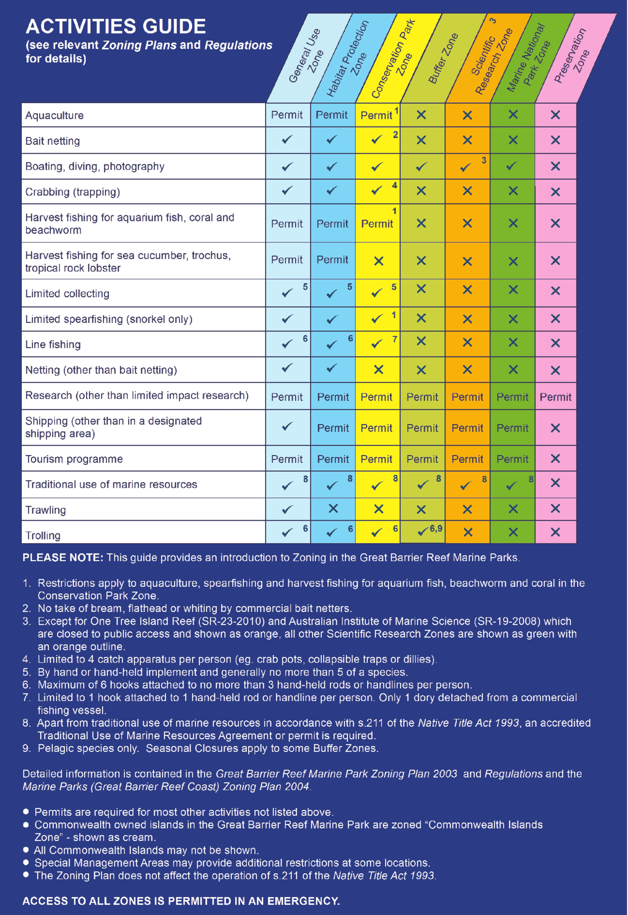 |
| The QLD Marine Park activity guide to the coloured zones. This guide is available on the zone charts available for download listed earlier. |
This link is for the plugin page in the OpenCPN manual detailing the Queensland Coast Zones. QLDCoastal Zones [OpenCPN Manuals]
Download the gpx files from here: GitHub- redog666/qld-coastal-zones: fishing zones
 |
| Download the zip file from Github and unzip into the GPX holding directory you create. |
 |
| Go to the Plugin tab of the OpenCPN options and install and enable OCPN Draw. |
 |
| Open up OCPN Draw |
 |
| New Persistent Layer opens up a window to find and select the GPX files for display |
 |
| Select the files required for display, I select files both sides of the zone I am operating in due to some zones crossing over into neighbouring zones. |
| The zones displayed, simply select the eye icon to turn of the file from display |
 |
| Same location as above the files displayed have been turned off by selecting the eye icon. |
 |
| Layers tab of the OCPN Draw program. |
No comments:
Post a Comment