During our pilgrimage home to Australia in 2019 we choose to go’ the path
less travelled’ and sail under the Suramadu Bridge, aka the Surabaya – Madura
Bridge. This passage was scorned by many (who clearly had not done the passage)
and at first we gave it a wide berth choosing instead to travel east along Java
and Madura’s north coastlines bound for the island of Raas. From there we planned
to drop down to the southern archipelago, Bali being the first stop then on to
Lombok, Komodo, Flores etc until our jump off point for Australia. The current
had been flowing strong in a westerly direction since getting to the Java north
coast. However we made allowances and motor sailed when needed to gain our
travel east. We were nearly at the jump
off point at the east end of Madura but the current and wind soon forced our
hands and we turn back. The body of water flowing around the eastern tip of
Madura proved too strong for us, mixed with a decent 2 – 3 mtr swell from the
east and 20-26 knot SE’ly winds (on our nose) we could not motor more than 1- 2
knots. The risk to our vessel was too great, so in the name of safety we turned
back and decided to go under the infamous Suramadu Bridge.
 |
| While sitting at anchor on the northern entrance, a local fishing boat passes #8 red beacon. Note the lean of the beacon in the current. |
During our travels since 2016 when we left Australia and even before
then, we have learnt a lesson: when asking others for advice and their opinions
you need to ask the right questions. For us that meant asking: has anyone actually
done the passage and when did they do the passage? Things change quickly in
Asia especially in Indonesia, so recent information is imperative to making a
well informed decision.
 |
| A local pilot boat heading out to assist another commercial vessel. |
We had let others who only spoke from speculation sway our original
passage making plans to bypass the bridge out of fear. It is said that the
strait is insanely busy, very shallow and full of hazards. Even knowing that
the current was strong on the eastern end of Madura when heading south this
still didn’t motivate us to review or change our plans. So once the current
made that decision for us and we turned back, we then stuck to our own ‘rules’, this time asking the right questions. Turned out recent passages made by a few boats,
one in particular with a taller mast than ours and a deeper draft confirmed the
passage was not only pleasant but safe, appropriately buoyed, with good depths
and well protected from the SE winds for the better part of the strait.
 |
| The lighthouse on Maduara was a very impressive sight, note the radar on top. |
 |
| One of many shipping yards. This one was on Madura's side. |
Once we had completed our overnight passage from the eastern end of
Madura back to the body of water between Madura and Java: Selat Surabaya, we
anchored at 06 56.47S, 112 43.19E in 8.3mtrs of water, east of the channel
behind the #8 red beacon and behind the small island of P. Karang Jamuang which
is used as a base for the pilot boats. For the remainder of the day we went
over our passage one more time. Feeling confident and well rested we took off
the next day at 0630.
 |
| One of many ferries, this one is at anchor. |
 |
| We passed countless numbers of tug & tows with their teak cargo. |
 |
| A sea of tug and tows ahead. |
The current plays a major factor in this journey. The current for the
strait floods South and ebbs North. We use Total Tide, which as it turned out
was very accurate and at one stage we had a 3 knot current with us –
sensational. The strait is very well charted with all its buoys and markers as
per Navionics. Yes the shipping traffic volume is a little crazy, but not unlike
crossing the Singapore Strait, most of the ships where at anchor. Those that
were on the move all had their AIS on allowing us to keep Matilda safe to one
side of the channel as they passed each time. Some of the locals who no doubt
don’t see a lot yachts in their part of the world here, were extremely friendly,
waving like mad as we passed them by. Amongst all the shipping traffic the
locals are fishing so be careful to watch out for their nets, again give them a
wave as you pass they are very happy people.
 |
| A couple of very friendly fishermen waving. |
 |
| And even more excited was the crew off one of the barges as we passed by. |
The bridge itself was approximately 20 nm’s from our chosen anchorage
point. The clearance as at HAT is 35mtrs according to Wikipedia. With our 18mtr
overall height of our mast, we had loads of clearance. The strait is one never
ending passing parade of vessels of all kinds: ships, ferries, tug and tows,
high speed craft, fuel barges, training vessels and the Indonesian Navy has a
substantial base on Java, just before you head under the bridge. Both the Madura and
Java sides of the strait are one never ending commercial venture, Java more so.
It is mind blowing what is going on here, it’s not the backwards place many
seem to think it is.
 |
| The Indonesian Navy base. All the ships are dressed in preparation for the celebration of their Independence as a nation. |
 |
| Some seriously tall stacks on Java's side. |
 |
| Our view to the Surabaya Bridge - just a few ships to dodge, who are all anchored. |
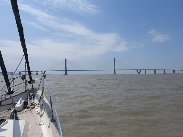 |
| Matilda, bound for the pass. |
Once under the bridge life is very different. After passing the first
red beacon, pick the ‘middle channel’ and angle to 135 degrees to remain in the
deeper water as marked. It does shallow
up some, but we never had any less than 3 meters under our 2 meter keel at a
full tide of 2.5mtrs. On the day we went through we did experience some wind
over tide as the SE’ly was not buffeted anymore and we were exposed. It was
approximately 35nm’s from our anchorage to the end of the shallow section. Although the chop eased as we moved further
east out to the Madura Strait and the body of water widened. Once we reached
the end of the ‘shallow’ section we had a sensational sail to our anchorage for
the night.
 |
| The officials buzzed past us most of the day, always waving and yelling out hello. |
What is amazing is once you go under the bridge (heading south) the
locals have built the most incredible ‘fence’s’ made of bamboo sticks so they
can catch fish in the nets. The first fence you come across heading south runs
both to Madura and to Java. The gap (as per the chartered deeper water) was
around 07 12.90S, 112 50.10E: this is where the opening is to pass through.
Again this may sound daunting but the channel is well marked, as per Navionics.
Our second fence was at: 07 15.13E, 112 51.98E, but this fence ran only back to
Java and was easily seen. We felt confident passing the fences as commercial
shipping use this lane. Unless you have a track to follow we would not advise
to do this path at night.
 |
| Fences of flags looking towards Java. |
 |
| More fencing all running towards Madura. |
Our total passage was 52.8nm’s and took us 11 ½ hours total. We dropped
anchor along Java’s coastline at Tg. Warangan: 07 38.21E, 113 00.70S behind the
breakwater wall for the power station. This position is amongst an exceptional
amount of squid houses and we would not advise anyone to enter at dusk or at
night, clear vision is essential.
 |
| Our home for the night was beside this power station. |
 |
| A little bit hard to see but right up the top of this photo shows a few squid houses. In the centre is a whale shark splashing around. |
The bonus to those who choose this route and stop by this anchorage will be the whale sharks who feed
here. We finished our day off having a very cold beer in the cockpit watching approximately 8 of these incredible creatures swim around Matilda, with their mouths wide open catching their dinner!
 |
| A whale shark close by Matilda, mouth wide open catching dinner. |
Safe travels.
 |
| A squid house in the sunset. |


No comments:
Post a Comment